


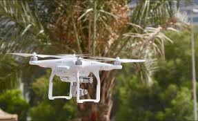
UAE completes pilot phase of mapping agricultural areas using drones
DUBAI: Using drones, the UAE has completed the pilot phase of a research project to map agricultural areas across the country designed to enhance food production despite challenging geographic conditions.
The UAE Ministry of Climate Change and Environment (MOCCAE) said the project is aimed at facilitating future agricultural support services with the scheme providing a wealth of raw data for analysis, such as the number and
size of crop, livestock, and mixed farms as well as cooled and regular greenhouses, soil typeand condition, crop diseases, and irrigation methods.
The Ministry said the initiative will also help monitor agricultural productivity, including seasonal crops (vegetables and field crops) and year-round crops (fruits) in its ambit, to devise adequate marketing plans for farmers. In addition, areas cultivating feed crops will also be assessed as part of the mapping exercise to help MOCCAE identify the types of feed that need to be imported.
“Through leveraging drones for spatial data collection on farms, we seek to establish an accurate database of actionable statistical information to inform decision making and planning. The scheme will assist us in optimizing the allocation of agricultural resources,” said Dr. Thani bin Ahmed Al Zeyoudi, Minister of Climate Change and
Environment.
Once completed, the project will place the UAE among the top five countries in the world in terms of area surveyed using unmanned aerial vehicles, and the first to employ this technology to map as many as 22 categories of statistical data
Related posts:

Dubai's mighty dhow combining tech and old craftsmanship ready to transport cargo from the UAE to Ye...
Almost the size of an American football field floating in the Indian Ocean, 'Oba...
MBRSC marks 1st anniversary of historic launch of first Emirati to space as it looks ahead with Hope...
DUBAI: The Mohammed Bin Rashid Space Centre (MBRSC) marked with pride the first ...
Largest mushroom farm in UAE relies on solar energy and tech to thrive
DUBAI: The largest mushroom farm in the UAE which produces about nearly 6 tons o...
DEWA taps Dell Technologies for future digital solution
DUBAI: The Dubai Electricity and Water Authority (DEWA) has reached out to Dell ...
Abu Dhabi invests $100m forNextGen agriculture in the desert
ABU DHABI: With investment totaling AED367 million (USD100 million), four agri-t...
Bahrain's F1 circuit to build COVID-19 ventilators and share blueprints worldwide
MANAMA: Bahrain's legendary F1 circuit will produce hundreds of ventilators for ...
10 things we've learned about the sun from NASA's SDO this decade
NASA's Solar Dynamics Observatory (SDO) marked its 10th year in space in Februar...