


Volga-Dnepr transports new ESA satellite mapping climate data
LONDON: The long-term partnership between Airbus Defence and Space and Volga-Dnepr Airlines has ensured the safe and timely delivery of the European Space Agency’s (ESA) Sentinel-5P satellite, which will provide air quality and climate data for the entire planet every single day after its launch in October.
Volga-Dnepr, which has been carrying satellites to launch sites around the world since 1990 for leading aerospace customers, says forward bookings for satellite flights for the remainder of 2017 and 2018 reflect a healthy outlook for this highly specialist market.
This year the airline has delivered satellites to the Cayenne launch site in French Guiana, Baikonur in Kazakhstan, Vandenberg in California, and Cape Canaveral in Florida.
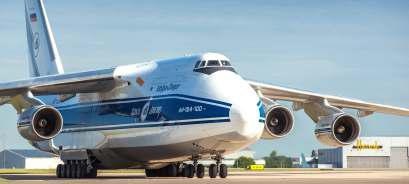
The Sentinel-5 P satellite was transported in a special container along with support equipment for its An-124-100 freighter flight from London Stansted to Archangelsk in the northwest of Russia. The loading process was accomplished using the An-124-100’s internal crane, two nitrogen purge containers were also used to keep the satellite container topped up with nitrogen.
Weighing six tons, the container measured 5767x2820x2621mm. The cargo was delivered to London Stansted Airport from the Airbus Defence and Space facility in Stevenage, where the satellite was put together and tested. Following its arrival in Archangelsk, the satellite completed the final 250km of its journey by train to Russia’s Plesetsk spaceport.
Alexander Kraynov, Commercial Director at Volga-Dnepr Airlines, said:“Working closely with our partner, Airbus Defence and Space, we have once again demonstrated our expertise in moving high value & highly sensitive satellite technology. The Sentinel-5P will now undergo further tests in Plesetsk over the coming weeks ahead of its scheduled launch on 13 October.”
With a swath width of 2600 km, the Sentinel-5P satellite will map the entire planet every day, delivering global maps of air pollutants in more detail than ever before. It will provide timely data on a multitude of trace gases and aerosols affecting air quality and climate.